You Won’t Believe What Lies Beneath Battambang’s Quiet Surface
Cambodia’s Battambang often flies under the radar, but beneath its sleepy charm lies a world of geological wonder. I discovered surreal landscapes—limestone karsts, hidden caves, and rice-field valleys carved by ancient forces. This isn’t just travel; it’s exploration. Few tourists venture deep, making it perfect for those craving authenticity. Let me take you beyond the map, where nature tells stories through rock and river.
The Hidden Face of Battambang
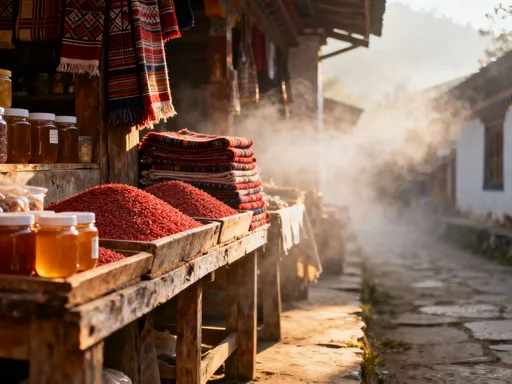
Battambang is widely celebrated for its well-preserved French colonial architecture, vibrant arts scene, and gentle pace of life along the Sangker River. Most guidebooks highlight its charming riverside cafés, vintage cinema halls, and colorful markets. Yet, beyond these cultural treasures lies a dramatic and largely overlooked natural realm—one shaped by tectonic shifts, ancient waterways, and slow, persistent erosion. While travelers stroll through town snapping photos of yellow-walled buildings with shuttered windows, few realize that just a short journey outside the city, the earth reveals far older narratives written in stone.
This quieter, wilder side of Battambang remains hidden not because it lacks grandeur, but because it lacks promotion. Unlike the temples of Siem Reap or the beaches of Sihanoukville, Battambang’s geological wonders do not dominate tourism campaigns. They are not framed by glossy brochures or featured in viral travel reels. Instead, they rise silently from the flat plains—jagged limestone towers, fissured cliffs, and subterranean caves—waiting for those willing to look beyond the surface. The region’s natural history is as layered as its rock formations, shaped over millions of years by forces both visible and invisible.
For the thoughtful traveler, especially one who values authenticity and discovery, this obscurity is a gift. It means uncrowded trails, unspoiled vistas, and the rare chance to witness landscapes untouched by mass tourism. The absence of large tour groups allows for deeper connection—not just with the environment, but with local farmers, guides, and families who live in harmony with this terrain. Battambang’s true identity is not only in its colonial facades but in the raw, sculpted earth that cradles them. To see only the town is to miss half the story.
Karst Kingdom: Towers of Time
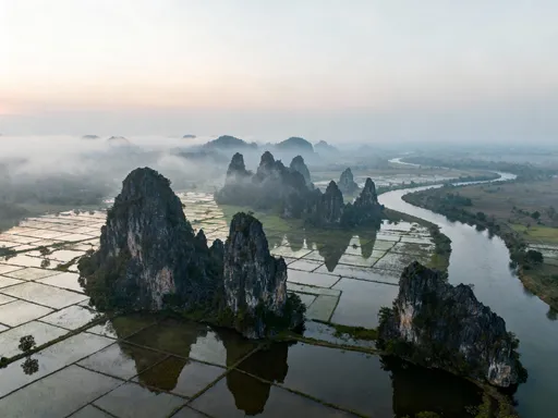
Rising abruptly from the emerald rice fields surrounding Battambang are towering limestone karsts—ancient remnants of a submerged tropical sea that once covered much of Southeast Asia. These formations, some reaching over 200 meters in height, appear almost surreal against the flat agricultural landscape. Their jagged silhouettes stand like sentinels, weathered by centuries of monsoon rains and tropical sun. Up close, the rock surfaces reveal intricate patterns—ripples, grooves, and honeycombed textures—each telling a chapter in a geological story millions of years in the making.
These karsts originated during the Mesozoic era, when calcium-rich sediments accumulated on the ocean floor. Over time, tectonic activity uplifted the seabed, exposing these deposits to the atmosphere. Once above water, the slow work of erosion began. Rainwater, slightly acidic from absorbing carbon dioxide, seeped into cracks in the limestone, gradually dissolving the rock and widening fissures. This process, known as chemical weathering, created the dramatic peaks, sinkholes, and underground drainage systems visible today. The result is a landscape that feels both alien and deeply rooted in natural law.
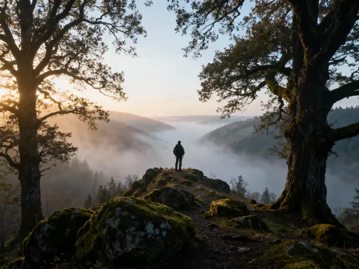
One of the most accessible vantage points is Phnom Sampov, a hill on the western edge of town that offers panoramic views of the surrounding countryside. From its summit, the karst formations stretch into the distance like a broken crown. At dawn, when mist clings to the valleys and soft light gilds the treetops, the scene evokes a sense of timelessness. But beyond this well-trodden spot lie countless lesser-known outcrops—remote, unnamed, and unmarked on most maps. These hidden formations are often known only to local farmers and children who climb them after school, their names passed down through generations in Khmer folklore.
What makes these karsts especially compelling is their contrast with the surrounding farmland. While the rice paddies represent human cultivation and seasonal rhythm, the limestone towers stand as monuments to deep time—unchanging, enduring, indifferent to the cycles of planting and harvest. Walking among them, one feels both small and connected, a fleeting presence in a landscape shaped by forces far greater than any single life.
Caves Beyond the Tourist Trail
Within the heart of these limestone formations lie cave systems formed by the same slow, persistent action of water. As rain percolated through the rock over millennia, it carved out underground chambers, tunnels, and dripstone galleries. Some of these caves are known to visitors, such as the Bat Cave at Phnom Sampov, where millions of wrinkle-lipped bats emerge at dusk in a swirling, deafening cloud. But beyond this popular spectacle are quieter, less accessible caverns—natural sanctuaries that remain largely unexplored by outsiders.
Entering one of these caves is an immediate sensory shift. The outside heat gives way to cool, damp air. The noise of cicadas and motorbikes fades into a profound silence, broken only by the occasional drip of water echoing through hollow chambers. The walls, smooth in some places and jagged in others, bear the marks of ancient flows—stalactites hanging like stone icicles, stalagmites rising from the floor, and flowstones that resemble frozen waterfalls. These formations grow at an almost imperceptible rate—sometimes less than a millimeter per year—making them living records of geological time.
While some caves have been adapted for tourism, with wooden walkways and electric lights, others remain in their natural state. These untouched caverns require flashlights, sturdy footwear, and local guidance to navigate safely. They are not places of spectacle but of stillness—a chance to stand where few have stood, to touch rock that has not seen sunlight for millions of years. The experience is humbling, a reminder that the earth holds spaces beyond human reach and understanding.
Historically, some of these caves served as shelters during periods of regional instability. Local accounts mention their use by communities seeking refuge, though specific details are often shared with discretion. There is no evidence of widespread ritual use or religious significance, and such claims are best left unmade without clear cultural context. What is certain is that these caves have long been part of the local landscape—not as tourist attractions, but as natural features woven into daily life, known to those who live nearby and respected for their quiet power.
River Cuts and Ancient Valleys
The Sangker River, which flows gently through Battambang town, is far more than a scenic waterway. It is a sculptor—one that has carved deep into the soft limestone and alluvial deposits over thousands of years. As it winds westward toward the Tonlé Sap, the river has cut narrow gorges, exposed rock layers, and shaped a network of valleys that reveal the region’s geological history in cross-section. These features are subtle, often overlooked by those who see the river only as a backdrop for boat rides or riverside dining.
Fluvial erosion—the process by which flowing water wears away rock and soil—has been the dominant force in shaping this landscape. During the wet season, the Sangker swells with runoff, increasing its velocity and carrying capacity. It picks up sediment, grinds against riverbanks, and gradually deepens its channel. Over time, this persistent action has created sinuous bends, undercut cliffs, and exposed fossil-rich strata. In some areas, the river has cut so deeply that limestone ledges rise vertically on either side, forming natural amphitheaters hidden from view.
One of the most effective ways to appreciate this quiet drama is by boat. Local wooden vessels, powered by small engines or paddled by hand, glide along stretches where the river narrows and the banks rise steeply. From this vantage, travelers can see layers of sedimentary rock stacked like pages in a book, each representing a different geological era. Fossilized shells and marine fragments embedded in the cliffs are silent proof of a time when this entire region lay beneath a shallow sea.
These river-carved valleys also influence local agriculture. The natural drainage patterns created by the Sangker help prevent prolonged flooding in nearby fields, while seasonal overflows deposit nutrient-rich silt that enhances soil fertility. Farmers have long understood this relationship, planting rice and vegetables in areas that benefit from the river’s rhythm. The connection between water, land, and livelihood is not merely economic—it is deeply ecological, a cycle sustained by natural processes that predate human settlement.
Rice Fields on Fractured Earth
The vast, shimmering rice fields that blanket Battambang’s lowlands are among Cambodia’s most productive. What many do not realize is that this agricultural abundance is built upon a complex and dynamic geological foundation. Beneath the surface, the land is fractured—crisscrossed by fault lines, ancient riverbeds, and eroded bedrock. These hidden structures influence water movement, soil composition, and land stability, creating conditions that are surprisingly favorable for farming.
Seasonal flooding plays a crucial role. As monsoon rains fill the Sangker and its tributaries, water spreads across the plains, soaking into fissures and recharging underground aquifers. When the floodwaters recede, they leave behind a layer of fine silt rich in minerals—nature’s fertilizer. This cycle, repeated year after year, sustains the fertility of the soil without the need for heavy chemical inputs. Farmers plant their crops with an intuitive understanding of these patterns, timing their sowing to coincide with the retreat of the waters.
The presence of limestone bedrock also contributes to soil health. As it weathers, it releases calcium and other nutrients into the soil, improving its structure and buffering pH levels. In areas where the rock is closer to the surface, farmers often find naturally elevated plots—small mounds formed by differential erosion—that provide excellent drainage during heavy rains. These micro-landforms, though modest in size, can make the difference between a successful harvest and crop loss.
To walk through these fields is to witness a quiet collaboration between human labor and geological history. The farmers do not study tectonic maps or sediment layers, yet their practices align with the land’s deep rhythms. They work on ground shaped by forces they cannot see, cultivating food on terrain forged by ancient seas, uplifted rock, and flowing water. Their knowledge is passed down through generations, not in textbooks, but in the timing of planting, the choice of seeds, and the careful management of water.
How to Explore Responsibly
As interest in Battambang’s natural wonders grows, so does the responsibility to protect them. These landscapes are fragile—limestone erodes easily, cave ecosystems are sensitive to disturbance, and rice-field hydrology can be disrupted by unchecked development. Travelers have a vital role to play in preserving this region’s integrity by choosing low-impact, respectful ways to engage with the environment.
One of the best ways to explore is with a local guide. Residents often possess detailed knowledge of safe trails, hidden viewpoints, and seasonal conditions that are not available in guidebooks. Hiring a guide supports the local economy and ensures that visits are conducted with cultural and environmental sensitivity. Guides can also help prevent accidental damage—such as stepping on delicate stalagmites or straying into protected areas—by leading visitors along established, sustainable paths.
Transport choices matter, too. The iconic bamboo train, or *nori*, offers a fun and eco-friendly way to travel short distances along disused rail lines. Bicycles are another excellent option, allowing travelers to move quietly through villages and countryside while minimizing emissions. Motorbikes and cars should be used sparingly, especially on unpaved roads that can erode quickly during rains.
Visitors should also respect designated protected zones. Some karst areas and caves may be closed to the public to prevent damage or preserve ecological balance. These restrictions should be followed without question. Littering, carving names into rock, or removing natural materials—even small stones or shells—should be strictly avoided. The goal is not just to observe, but to leave no trace.
Timing is another consideration. The dry season, from November to April, offers the best conditions for hiking and cave exploration, with lower humidity and safer trail conditions. Early morning visits not only provide cooler temperatures but also increase the chances of seeing wildlife and experiencing the landscape in its most serene state. By planning thoughtfully, travelers can enjoy Battambang’s wonders without compromising their future.
Why This Secret Matters
The geological treasures of Battambang are more than scenic backdrops—they are part of a living, breathing system that sustains both nature and community. They remind us that beauty is not always loud or famous; sometimes, it lies in the quiet persistence of water carving rock, in the slow rise of a stalactite, in the rhythm of rice growing on ancient seabed. These landscapes are not just to be seen, but understood and protected.
In an age where many destinations are overwhelmed by tourism, Battambang offers a different model—one of depth, respect, and mindful discovery. It challenges travelers to look beyond checklists and selfies, to engage with place on a deeper level. When we take the time to learn how a valley was formed or how a cave was shaped, we develop a stronger emotional connection to the land. This connection fosters stewardship, encouraging us to act as caretakers rather than mere visitors.
Preserving these hidden wonders also supports sustainable development. Eco-conscious tourism creates jobs, funds conservation efforts, and promotes pride in local heritage. It allows communities to benefit from their natural assets without sacrificing them to short-term gain. Battambang has the potential to become a leader in responsible travel—not by becoming more famous, but by staying true to its quiet strength.
To uncover what lies beneath Battambang’s surface is to rediscover the essence of travel itself: curiosity, wonder, and a sense of belonging to something greater. The earth keeps its secrets well, but for those who listen, it tells stories of time, transformation, and resilience. Let us be the kind of travelers who do not just pass through, but pay attention—before these quiet masterpieces fade from memory, unnoticed and unloved.